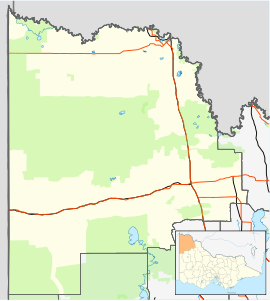
Lindsay Point, Victoria
Appearance
| Lindsay Point Victoria | |||||||||||||||
|---|---|---|---|---|---|---|---|---|---|---|---|---|---|---|---|
| Coordinates | 34°06′00″S 141°01′01″E / 34.10°S 141.017°E | ||||||||||||||
| Population | 38 (2016 census)[1] | ||||||||||||||
| Location | |||||||||||||||
| LGA(s) | Rural City of Mildura | ||||||||||||||
| State electorate(s) | Mildura | ||||||||||||||
| Federal division(s) | Mallee | ||||||||||||||
| |||||||||||||||
| Footnotes | Adjoining localities[3] | ||||||||||||||
Lindsay Point is a locality in northwestern Victoria, Australia, located approximately 130 km from Mildura. Its northern extremity, located at 33.981°S 140.963°E, is less than one kilometre from the South Australian town of Murtho and is notable for being the only location in Victoria that lies to the west of a portion of the state of South Australia.
References
[edit]- ^ Australian Bureau of Statistics (27 June 2017). "Lindsay Point (SSC)". 2016 Census QuickStats. Retrieved 14 July 2020.
- ^ Travelmate Archived 2007-03-24 at the Wayback Machine
- ^ "Mildura Rural City town and rural districts names and boundaries" (PDF). Locality names and boundary maps. Department of Environment, Land, Water and Planning, State Government of Victoria, Australia. Archived from the original (PDF) on 18 October 2015. Retrieved 5 September 2016.


